|
"AIS -
Using the Benefits of the Automatic Identification System"
What is AIS and who
has it?
The Universal Shipborne Automatic Identification
System (AIS) is a vessel tracking system capable of communicating
navigation information automatically between AIS equipped vessels
and coastal authorities. Vessels equipped with a receiver can
also benefit by knowing the whereabouts and intentions of these
ships. AIS provides a tool for improved safety and collision
avoidance. Since 2004, the International Maritime Organization
(IMO) has instituted carriage requirements for vessels affecting
both worldwide and local shipping traffic. These carriage requirements
apply to commercial vessels subject to the Safety of Life at
Sea (SOLAS) convention.
In a very general sense, the AIS system
is similar to the air traffic control system only applied to
marine traffic. This mandatory regulation requires all vessels
over 300 tonne on an international voyage and all domestic vessels
over 500 tonne to have an AIS transponder installed. Passenger
ships irrespective of size are also required to carry an AIS
transponder. Local authorities may have additional requirements
subject to the area's traffic. Ships are aware of each other's
position and harbour control can use AIS to increase transportation
efficiency and safety by identifying, tracking and supervising
the movement of these large vessels as they head into harbour,
or navigate along in-land waterways or dangerous coastlines.
AIS data is sent every few seconds over
two dedicated digital marine VHF channels. The transmission interval
varies based on speed and for those changing course; faster and
turning vessels are updated more frequently. The AIS transponder
works in continuous mode regardless of whether the vessel is
off-shore, within coastal or inland waters, or at anchor. Moored
and anchored vessels broadcast their position less frequently.
Ships send data related to vessel movement
including current position, speed, course, rate of turn (ROT)
and others. Information about the ship and its voyage is sent
less frequently. This data includes the IMO number (unique to
the ship), call sign, name, length and beam of vessel and the
location of the position fixing antenna for the AIS signal. Voyage
information including the type of vessel (ex. cargo, tanker,
hazardous cargo), destination and ETA are sent out as well.
Signal coverage for AIS is similar to
other VHF applications and depends on the height of the antenna.
Typical ranges are 20 nautical miles. We have have seen this
range with our antenna on the radar pole which is just above
the bimini. Others have successfully placed a spare antenna on
the rail. Even a coat hanger lying on the chart table serving
as a temporary antenna was receiving ships 8-12 nautical miles
away!
Because VHF frequencies have a longer
wavelength and better propagation, AIS signals have an ability
to "see" behind islands or around bends in a river,
where a radar cannot. This aspect of the AIS signal can add to
safer navigation by detecting the whereabouts of a ship, even
when it is out of sight behind a headland or island.
Aids to navigation can be transmitted
over AIS. These can be physical aids like buoys or "virtual"
ones to mark a new or transient danger such as a wreck. AIS can
also identify navigational aids that are not in their charted
position.
Additionally, safety messages can be
issued from either a ship or shore-based stations. A ship that
is adrift may issue a broadcast warning "adrift with no
engine". Safety messages also may include meteorological
broadcasts or search and rescue information.
How does this system benefit coastal
mariners?
The AIS system has many features that
can bring enormous benefits and collision avoidance data to safety-minded
mariners especially when maneuvering in crowded commercial harbours,
along busy coastal waterways and shipping channels and for short-handed
crews. AIS does not replace standing a proper watch, but it can
add improved situational awareness for the watch-keeper and since
the system constantly updates, real-time changes of another ship's
movements are immediately recognized.
Targets (ships) are easily identified
because the name is broadcast to the receiving station. Making
contact by actual ship name, instead of calling "ship off
my port bow", or "tanker at position latitude X, longitude
Y" increases the likelihood of a positive response to the
call. If your vessel has digital selective calling, you can punch
in the MMSI number that AIS provides to ring the bridge of the
ship directly.
The system also greatly increases safety
at night and AIS signals are received in poor conditions such
as heavy rain and squally conditions where a radar would show
only noise.
What options are available & useful
for interpreting AIS data?
The transmissions from AIS equipped
vessels are received and decoded by an AIS receiver. The AIS
receiver produces a NMEA data stream which when input to one
of a variety of electronic options for further decoding provides
usable navigation data. The data can be displayed on modern chart
plotters, with a dedicated AIS display or with computer software.
Products vary widely in their features
for display and alarm capabilities. Many calculate and sound
alarms based on the closest point of approach (CPA). The CPA
is the minimum distance your vessel will come with the target
if both maintain their speed and course. AIS enhances this feature
because signals are received miles in advance of the CPA actually
occurring. Based on your current course and speed you know that
an intercept of your vessel and the on-coming ship will occur
in a given time (TPCA); you also know just how close that distance
will be (CPA).
Systems with CPA alarms sound a warning
when the AIS target is first received and typically sound only
when alarm criteria are met. Customizable alarm parameters allow
the user to define the distance a ship will be predicted to come
before an alarm is sounded. This may be especially important
depending on whether you are maneuvering in a crowded harbour
or off-shore. For harbour sailing one would typically want a
smaller CPA because of the amount of traffic operating closely
and specifically; coastal or off-shore scenarios generally have
greater CPA values.
CPA alarms are superior over range alarms
because of their advance warning and they are target specific.
Similar to radar guard zones, when alarms are based on range
the target must already be within the predefined circle or range
before an alarm sounds. Some ships may be within range, hence
sounding the alarm, but pose no collision risk because they are
headed away or running parallel for example. The alarm will sound
constantly with this scenario and most mariners turn the alarm
off until the vessel passes out of the prescribed range but this
means another target may go undetected. Often times the watch-keeper
forgets to return the guard alarm to its active state, providing
no alarm benefit at all.
Another benefit of AIS includes the
ability to filter and prioritise targets. In a crowded harbour
many vessels are moored in port or anchored awaiting to off-load
their cargo. False alarms are greatly reduced by filtering out
vessels or suppressing alarms for targets that are not moving,
hence posing no collision risk, as one moves through the harbour.
AIS data can be displayed providing
a live, real-time graphical display of marine traffic. The display
provides an interesting visual representation for the location
and movement of the ships and the target's AIS navigation data,
but without some kind of prioritisation system, the navigator
won't necessarily know which of the vessels pose a collision
risk. The closest ship may not be the number one safety concern.
Crowded harbours and busy shipping lanes typically have numerous
targets. How do you know which of the vessels pose the highest
risk, especially when there are 80 to 100, or even 30 ships on
your chart?
Cruising with AIS
As we all know, large ships move fast,
have limited maneuverability, can't always see smaller vessels
or sadly, aren't always looking for them. Given their mass and
speed, they can't stop without planning for this event well in
advance. Sailors hold these behemoth vessels with great respect
and most identify with an underlying fear of being run down ranking
high on the safety checklist.
As interested cruisers, we bought an
AIS receiver a couple years ago intrigued by the system and its
potential benefits for marine safety. We soon found out that
just a receiver was not going to provide much information - you
also needed some way to interpret and display the data. We started
evaluating what products were available and in particular how
alarm features worked for given systems.
Through this discovery process we developed
a stand alone collision warning display and alarm. It is one
of several options that can help you maintain a safe watch at
sea. AIS is an invaluable tool and source of navigation information
which can be used to your benefit: it should not be solely relied
upon in making navigation and collision-avoidance decisions.
The Options:
The available options for interpreting,
displaying and utilizing AIS depends in part on your boat systems
and personal choice. If you already have a chart plotter that
supports AIS, it may be the fastest and simplest road to using
the benefits of AIS. Many modern chart plotters support receiving
AIS data. The targets are represented as triangles which overlay
an electronic chart, each typically showing a vector to indicate
the direction of movement. Additional data about a specific target
can be gained by moving the cursor over each target.
Smaller and less expensive chart plotters
tend to have very crowded screens displaying lots of chart information
condensed to a small area. All this data, along with the icons
for each AIS target are present. Many manufacturers have CPA
alarms to warn if a ship will pass dangerously close, but it
is often necessary to cursor to the ship in question to determine
more information about the alarm. If it doesn't have filtering
the false alarms may be a big nuisance. If it doesn't prioritise
targets and alarms, then determining which targets to pay attention
to first may be tricky, particularly in crowded shipping areas.
If power consumption is not a concern,
another means of using AIS data is with a receiver and charting
software for the computer. There are a variety of packages that
support AIS incorporating an external receiver. They all work
basically like the chart plotting scheme mentioned previously,
but because laptops usually have a larger screen there is more
area for all the data.
The challenge comes with leaving the
laptop running: power consumption is high for computers. Most
sailing vessels do not have the luxury to run their computers
all the time. If you shut off the computer you have no alarms
and you must wait to boot up the computer before you can learn
anything about a ship you might see coming at you.
One of the many beauties of the AIS
system is that it has the potential to notify you well in advance
of an oncoming ship, along with collision avoidance alarms for
ships you might not see. Laptops are also known to mysteriously
shut down, break down, or go flying, all of which will hinder
AIS data interpretation.
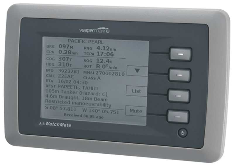
There are also dedicated stand-alone
AIS display units. These devices are designed to be left running
at all times and are solely dedicated to AIS interpretation.
Regardless of the type of display, features
to consider for AIS interpretation are their alarm capabilities,
especially for CPA alarms and filtering options. Does it prioritize
targets and alarms? Is it waterproof? Can it be at or near the
helm to provide benefit when and where its needed? Does it receive
AIS transmitted aids to navigation and safety messages ? Is the
unit 'upgradeable'? Does it support the ability to switch to
a different type of AIS receiver or possibly to a class B transponder?
How many targets can it track? Does the display support both
class A and class B AIS data? How much power does the unit use?
Can it be left on all the time? These are some of the questions
you might keep in mind when evaluating your navigation needs
and the applications of AIS technology.
Receivers and Transponders
A variety of receive-only devices is
currently available. All receiving units accept AIS data from
either of two dedicated VHF channels. The data is sent every
few seconds, but alternately between each channel. The two channels
are in place for redundancy.
Dual channel receivers are available
as scanning (multiplex) or full-time dual channel units. The
multiplex unit receives data over one channel at a time, but
will automatically switch to the alternate channel if interference
is detected. The dual channel receiving unit receives both channels
simultaneously and consolidates the information into a single
data stream. All AIS data will be received, but the dual channel
unit updates the data more frequently. Some AIS receivers have
a built-in GPS unit. Single channel receiving units are also
available, but are not recommended.
Transponders not only send data but
are also two channel receivers. However, like a receive only
unit, transponders also require an interpretive or display head
in order to gain the navigation benefits of AIS. There are two
types of transponders used for AIS. Class A is intended for use
to meet the IMO mandated carriage requirements for commercial
ships. Class B was developed after the introduction of class
A and is designed to be compatible with the the safety operation
of class A. It is targeted for use on smaller vessels but has
a simplified installation and a lower cost as compared to class
A. Class B does not send data as frequently, nor does it use
all of the same fields of data as class A, but can still provide
safety and navigation benefits to smaller vessels.
The availability of class B transponders
is increasing amongst smaller commercial boats, fishing and work
boats and for recreational boaters as manufacturers bring more
products to market. Being "seen" by using a Class B
transponder does not guarantee that the bridge of the receiving
ship reads your signal. The ship may not have AIS data displayed
or may not be looking at it. Carriage requirements specify that
they only send their AIS data and does not require them to have
more than a minimal display device aboard. Some ships may not
receive class B signals at all or may choose to filter them out.
How the class A traffic deals with increasing and potentially
high numbers of class B fitted boats remains to be seen; this
situation may become a problem as class B traffic increases.
As teenagers we learned defensive driving
when we first received our license. As prudent mariners and sailors
it is to our benefit to take an active role in defensive collision
avoidance. Your vessel may have right of way, but it is much
easier for you to maneuver out of a big ship's way to avoid a
dangerous situation - especially when you know more about his
movement. AIS data is there for the taking. It's use has the
potential to save lives.
More Resources
For further reading on AIS and product
information:
www.navcen.uscg.gov/marcomms/ais.htm -- US coast guard
site on AIS
www.shipadm.org/upload/1486/a171_2.pdf
- Swedish Maritime Administration
www.panbo.com - blog site with valuable and interesting AIS
Section
www.gcaptain.com - blog
by ship captains about ships
www.vespermarine.com - AISWatchMate™ Collision warning alarm |